
Course characteristics
Difficulty scale
RMT
8
Mountain value
G
5
Class group

Ultra
Mountain value group
G
Regular
Distance
⨦ 165.5 km
Flat equivalent
Uphill
+ 7 550 m
Downhill
- 7 550 m
Location
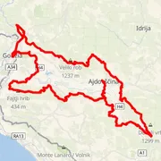
Ajdovščina, Slovenija
Time predictions
Check your potential! Estimate your finish time, see if you can run the course in a certain time, or maybe you'll compete for the win?
Check nowElevation profile
Highest point
1 486 m a.s.l.
Lowest point
40 m a.s.l.
Elevation range
1 446 m
Podrta gora ~ 855 m a.s.l.
⨦ 7 km
Pravi vrh (Vrh Podrta gora) ~ 830 m a.s.l.
⨦ 8 km
Črne stene ~ 836 m a.s.l.
⨦ 8.5 km
Navrše ~ 857 m a.s.l.
⨦ 10.5 km
Dolski maj ~ 913 m a.s.l.
⨦ 14.5 km
Mali Golak ~ 1 495 m a.s.l.
⨦ 22 km
Veliki Modrasovec ~ 1 355 m a.s.l.
⨦ 29.5 km
Mala gora ~ 1 032 m a.s.l.
⨦ 32 km
Črna peč ~ 1 148 m a.s.l.
⨦ 34 km
Kucelj ~ 1 237 m a.s.l.
⨦ 35 km
Sekulak ~ 888 m a.s.l.
⨦ 39 km
Vitovski hrib ~ 604 m a.s.l.
⨦ 41 km
Frančiškov hrib ~ 631 m a.s.l.
⨦ 57.5 km
Martinjak ~ 98 m a.s.l.
⨦ 78.5 km
Grabčji hrib ~ 206 m a.s.l.
⨦ 89 km
Cerje ~ 343 m a.s.l.
⨦ 90.5 km
Veliko Medvejšče ~ 376 m a.s.l.
⨦ 91.5 km
Veliki vrh ~ 463 m a.s.l.
⨦ 93.5 km
Renški vrh ~ 452 m a.s.l.
⨦ 94.5 km
Stolovec ~ 565 m a.s.l.
⨦ 97 km
Stol ~ 629 m a.s.l.
⨦ 98 km
Trstelj ~ 643 m a.s.l.
⨦ 99 km
Soknica ~ 296 m a.s.l.
⨦ 107 km
Sv. Martin ~ 331 m a.s.l.
⨦ 113 km
Ostri vrh ~ 422 m a.s.l.
⨦ 119.5 km
Mali hrib ~ 540 m a.s.l.
⨦ 132 km
Sveti Socerb ~ 555 m a.s.l.
⨦ 136.5 km
Strmec ~ 850 m a.s.l.
⨦ 146 km
Vrh Debele stene ~ 863 m a.s.l.
⨦ 146.5 km
Course information
Elevation data
Copernicus DEM 30 m
Number of events with this course
3
Event date
15 May 2020
Course statistics
Join to discover more!
Check your run history, analyze your achievements, and compare results with other runners.
Log in nowCourse variant code V-180 – this code is used to group course records in this event.
Your effort has a color
Amator
Beginner Level
Advanced Level
Expert Level
Elite
Rate My Trail © 2018 / 2026
Mountain Runners Ranking